Sea level rise driven by anthropogenic climate change presents a number of problems for the international relations discipline. This article is intended as an introductory primer on the impact of sea level rise on coastal societies, along with the economic, social and political implications of these impacts.

Rising Seas
Global mean sea level has risen by 3.4 millimetres per year on average since 1992. This doesn’t seem like much, but over time is likely to have an increasingly significant effect on human societies that are located in coastal areas.
Sea level rise is driven by three primary factors: the melting of glaciers and land-based polar ice-cap, thermal expansion of the sea, and local land subsidence. Because of this complex causation, the degree of sea level rise varies according to location.
Sea level rise express itself through three major mechanisms: encroaching high tide marks, storm surges, and salt water intrusion of fresh water reserves.
A tidal high-water mark—or strandline—is the highest position of the tidal cycle. Structures built directly on the foreshore will become increasingly vulnerable to regular tidal buffeting as the high-tide mark encroaches with rising seas.
Storm surges occur when strong winds from extreme weather events such as cyclones, hurricanes and typhoons push at the ocean surface, causing water to pile higher than the ordinary sea level. At the coast, storm surges push sea water inland beyond regular high tide marks. For example, the storm surge generated by Hurricane Katrina in 2005 measured up to 8 metres at locations along the US Gulf Coast.
In low-lying areas, storm surge events can contaminate fresh water sources. Surface and groundwater reserves are both vulnerable to salt water intrusion, a problem particularly acute in small island countries.
Coastal Impacts
So what does this mean then for large coastal population centres?
Let’s consider why many of the world’s big cities grew in their specific geographic locations. Often coastal settlements were established where inland river systems terminate at the sea, because these spots were excellent locations to establish trading hubs. This harks back to earlier times when river systems were like trans-continental highways, where river transport was the quickest way to move goods inland from international markets.
Today, many of the world’s mega-cities are located in such places, like New York at the mouth of the Hudson River, Shanghai in the Yangtze River delta, Kolkata at the mouth of the Ganges River, and London, just upriver from the Thames estuary.
Hundreds of millions of people worldwide live in coastal settlements large and small. People pay premium prices for water front real estate in some places. In others, people’s livelihoods are dependent on trades and industries linked to the sea. Large coastal population centres also require critical infrastructure like port facilities and airports, along with power stations, oil refineries, urban transportation systems and even agricultural land.Let me give you a few examples to illustrate the point:
In Victoria, think of the dockland precincts at Port Melbourne and Geelong, which link this state to international trade networks. For similar reasons, oil refineries are located on the coast—like the one at Altona west of Melbourne—to allow oil tankers to unload their cargoes of crude oil. And remember the critical role of oil as an energy source in modern industrial societies.
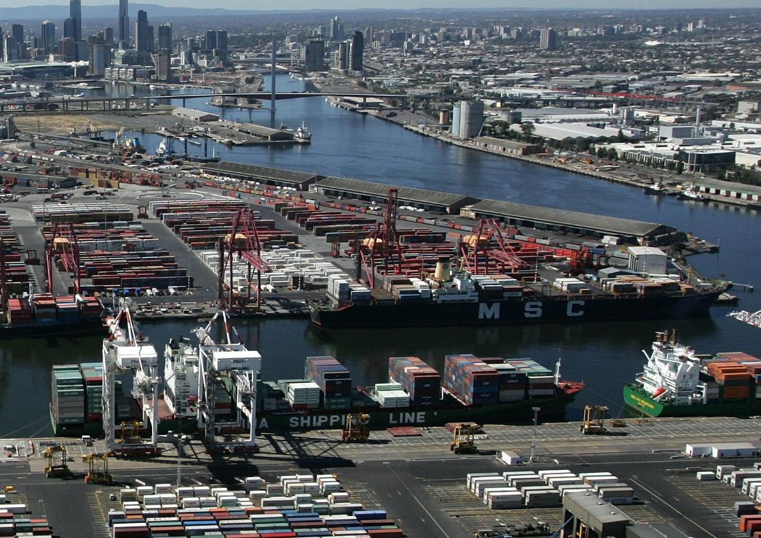
While we’re talking energy infrastructure, power stations are often located on the coast, to take advantage of sea water for their cooling systems.
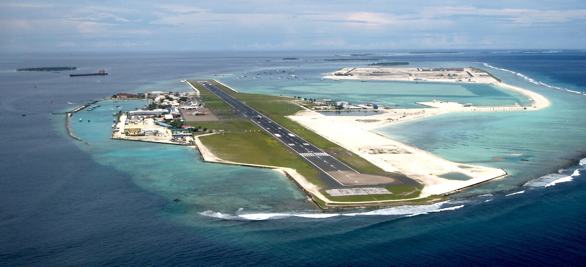
Airports are often located on land adjacent to the coast, or even on land reclaimed from the sea. Sydney’s Kingsford Smith airport in Botany Bay is a good example. The Ibrahim Nasir International Airport in the Maldives even lies 1 metre below sea level, behind specially constructed sea walls.
If we are concerned about neighbourhood travel, the vulnerability of urban transport networks was illustrated in New York by Super-storm Sandy in 2012, which flooded many parts of the city’s subway system.
I’m sure you’re starting to get the point. Sea level rise has the potential to threaten critical infrastructure, which themselves are critical to the economic vitality of the cities and countries that they service.
Sea Level and Sovereignty
Yet sea level rise has implications for relations between countries, in addition to its impacts on local human population centres.
A casual glance at a map of the world illustrates that the global land surface is carved up into discrete territorial entities called states. International relations is based on the concept of state sovereignty, which is the ability of a state to exercise control over and defend a defined territory, and the people and resources within that territory.
Now it’s easy to stake out state boundaries on land, using all manner of fences, walls, border posts and military installations. However states can also claim sovereignty over parts of the ocean. Here, in the maritime environment, it’s much more difficult to delineate boundaries, and these boundaries are often hotly contested and subject to dispute.
Oceanic territorial claims are governed by an international treaty called the United Nations Convention on the Law of the Sea, or UNCLOS. Under UNCLOS, there are four different levels of sovereignty that states can exercise over their adjacent seas.

The first 12 nautical miles from the coastline are a state’s territorial waters, in which it can exercise full sovereignty, where the state has full control over resource exploitation. All national laws apply, as they would on land.
There are other forms of maritime claim once we progress further than 12 nautical miles out to sea. The sea area from 12 to 24 nautical miles from the coast is called the contiguous zone, where states relinquish full sovereignty but where domestic regulations in customs, taxation, immigration and pollution remain in force.
From 24 nautical miles out to sea, UNCLOS includes two competing means of claiming maritime sovereignty. A state can claim an exclusive economic zone—or EEZ—up to 200 nautical miles from its shoreline. Here, it can claim exploitation rights over natural resources in the water column of the sea, on the sea floor, and under the sea bed. Usually this relates to fishing rights and rights to exploit oil and gas deposits under the sea floor.
In addition, a state can also claim rights over its continental shelf, to the end of the continental margin where the shelf drops off into deep ocean. A continental shelf claim can extend to either 200 nautical miles off-shore or to wherever the shelf ends, whichever is greater. In contrast to an EEZ, a continental shelf claim entitles a state to exploit resources on the sea bed and under the sea floor, but not in the water column itself.
No here’s the rub in terms of sea level rise. Maritime boundary claims are measured from a baseline that conforms more or less to the geographic contours of the coastline. If rising sea level changes the contours of the coastline then inevitably the associated maritime boundaries have to change as well, which presents many problems.
Because of the strategic and economic potential of undersea resources, maritime territorial claims often take decades to negotiate. Many claims are contested and remain locked in dispute. Countries often press their respective claims through hostile posturing and displays of military power, which can develop into armed conflicts if any of the disputing parties miscalculate.
Present-day disputes between China and Japan over the East China Sea, and China and a number of Southeast Asian countries over the South China Sea, are cases in point. In both cases there are significant oil and gas reserves up for grabs, which are a significant prize in a region that imports a majority of its energy needs from the Middle East.
So by altering maritime boundaries, sea level rise has the potential to re-open existing territorial and resources sharing agreements to renegotiation. Why? Because realigning the boundaries means redistributing potential resource gains. It will also complicate the politics of existing disputes, with the associated danger of raising tensions between rival claimants to dangerous levels.
An Existential Threat
For many low-lying island states, however, the threat of rising sea levels is far more severe.
You may remember a media stunt by the Maldives government in 2009, in the lead-up to the COP15 conference in Copenhagen, where the country’s Prime Minister and Cabinet held a ministerial meeting underwater in scuba suits. Their point was a powerful one: for them, climate change-driven sea level rise is an existential threat, a challenge to their very survival as a state.
For countries like the Maldives, Kiribati or Tuvalu, the sea level impacts I outlined earlier are already placing these countries under threat.
In Kiribati, for example, salt water intrusion is driving people from their homes in the country’s smaller islands to re-settle in the nation’s capital, South Tarawa. Because of this influx of displaced people, the population of South Tarawa has become over-crowded; its infrastructure is stretched to breaking point, with the city coming to experience many of the social problems associated with over-crowding and poverty.
On current sea level trends, the people of South Tarawa will ultimately have to leave here too.
In the short-term, governments of low-lying countries can employ adaptive measures like ocean barriers to cope with rising seas. In the longer term however, these adaptive responses will become too expensive and then completely ineffective, leaving migration as the only viable option.
There’s two ways to think about this: island residents could sell up and move abroad to countries like Australia and New Zealand, while their assets are still worth something. The government of Kiribati has a policy called “Migration with Dignity” that encourages just this.
But relocating to a new country and a foreign culture is difficult, especially in the absence of support networks of friends, family and community. Because of this, many people in island countries are choosing to stay. For them, migration will be an absolute final option. These people, unfortunately, will have few assets to fall back on when they eventually leave.
A great tragedy of these forced migrations may be the loss of unique cultures. National cultures around the world are heavily invested in the landscape, in the land in which each people inhabit. Yet how can a culture be preserved in the absence of its link with the land? How can a nation be preserved if it doesn’t have a homeland? Cultural preservation is therefore a major issue for island societies facing the threat of sea level rise.

Finally, we return again to the issue of state sovereignty, which poses a unique set of questions for low-lying island states. If low-lying states are completely inundated, are they still entitled to claim the rights and responsibilities of statehood? Will they retain recognition as states by other countries, which is the basis of statehood under international law? Will they retain voting rights in the United Nations and other associated international bodies? What happens to their treaty obligations under international law? Do the citizens of these countries maintain citizenship rights, or do they effectively become stateless persons? These questions don’t have answers yet because there is simply no precedent for this in modern international relations.
—
Further Information:
Alliance of Small Island States (AOSIS)
Brecht, Henrike, Susmita Dasgupta, et al. (2012). ‘Sea-Level Rise and Storm Surges: High Stakes for a Small Number of Developing Countries.’ The Journal of Environment & Development 21(1): 120-138.
Center for Remote Sensing of Ice Sheets: Sea Level Rise Maps
Houghton, Katherine J., Athanasios T. Vafeidis, et al. (2010). ‘Maritime boundaries in a rising sea.’ Nature Geosci 3(12): 813-816.
Lusthaus, Jonathan (2010). ‘Shifting Sands: Sea Level Rise, Maritime Boundaries and Inter-state Conflict.’ Politics 30(2): 113-118.
OzCoasts: Australian Online Coastal Information
—
This piece was compiled as a primer for students enrolled in the cross-faculty first year undergraduate subject Climate and Society at LTU. I have been involved with this subject since 2010 as a lecturer and tutor. In 2012 I presented one of three Climate and Society plenary lectures, entitled Climate Adaptation in North Korea.

[…] Ben Habib – ‘Sea Level Rise as an International Relations Problem: An Introduction‘…. […]